Resource geoscience
Type of resources
Keywords
Publication year
Topics
-
<div>In Australia, wide-spread sedimentary basin and regolith cover presents a key challenge to explorers, environmental managers and decision-makers, as it obscures underlying rocks of interest. To address this, a national coverage of airborne electromagnetics (AEM) with a 20 km line-spacing is being acquired. This survey is acquired as part of the Exploring for the Future program and in collaboration with state and territory geological surveys. This survey presents an opportunity for regional geological interpretations on the modelled AEM data, helping constrain the characteristics of the near-surface geology beneath the abundant cover, to a depth of up to ~500 m.</div><div> The AEM conductivity sections were used to delineate key chronostratigraphic boundaries, e.g. the bases of geological eras, and provide a first-pass interpretation of the subsurface geology. The interpretation was conducted with a high level of data integration with boreholes, potential fields geophysics, seismic, surface geology maps and solid geology maps. This approach led to the construction of well-informed geological interpretations and provided a platform for ongoing quality assurance and quality control of the interpretations and supporting datasets. These interpretations are delivered across various platforms in multidimensional non-proprietary open formats, and have been formatted for direct upload to Geoscience Australia’s (GA) Estimates of Geological and Geophysical Surfaces (EGGS) database, the national repository of multidisciplinary subsurface depth estimates.</div><div> These interpretations have resulted in significant advancements in our understanding of Australia’s near-surface geoscience, by revealing valuable information about the thickness and composition of the extensive cover, as well as the composition, structure and distribution of underlying rocks. Current interpretation coverage is ~110,000 line kilometres of AEM conductivity sections, or an area >2,000,000 km2, similar to the area of Greenland or Saudi Arabia. This ongoing work has led to the production of almost 600,000 depth estimate points, each attributed with interpretation-specific metadata. Three-dimensional line work and over 300,000 points are currently available for visualisation, integration and download through the GA Portal, or for download through GA’s eCat electronic catalogue. </div><div> These interpretations demonstrate the benefits of acquiring broadly-spaced AEM surveys. Interpretations derived from these surveys are important in supporting regional environmental management, resource exploration, hazard mapping, and stratigraphic unit certainty quantification. Delivered as precompetitive data, these interpretations provide users in academia, government and industry with a multidisciplinary tool for a wide range of investigations, and as a basis for further geoscientific studies.</div> Abstract submitted and presented at 2023 Australian Earth Science Convention (AESC), Perth WA (https://2023.aegc.com.au/)
-
<div>Gas production from the Inner Otway Basin commenced in the early 2000s but the deep-water part of this basin remains an exploration frontier. Historically, the understanding of plays in this region were largely model driven and therefore the ground-truthing of depositional environments (DE) and gross depositional environments (GDE) are critical. This aspect has been investigated for the Sherbrook Supersequence (SS) by the integration of legacy wireline and core data, with regional 2D seismic facies mapping of new and reprocessed data from Geoscience Australia’s 2020 Otway Basin seismic program. Core observations were matched to wireline logs and seismic facies with resulting well based DE interpretations calibrated to seismic resolution Regional GDE intervals. Integration of well and seismic observations lead to the compilation of a basin-wide Regional GDE map for the Sherbrook SS. This GDE map indicates the distribution of Sherbrook SS play elements such as source rock, seal and reservoir, especially across the Deep Water Otway Basin where well data is sparse.</div> Published in The APPEA Journal 2023. <b>Citation:</b> Cubitt Chris, Abbott Steve, Bernardel George, Gunning Merrie-Ellen, Nguyen Duy, Nicholson Chris, Stoate Alan (2023) Cretaceous depositional environment interpretation of offshore Otway Basin cores and wireline logs; application to the generation of basin-scale gross depositional environment maps. <i>The APPEA Journal</i><b> 63</b>, S215-S220. https://doi.org/10.1071/AJ22090
-
<div>Geoscience Australia’s Onshore Basin Inventories project provides a whole-of-basin inventory of geology, petroleum systems, exploration status and data coverage of hydrocarbon-prone onshore Australian sedimentary basins. Two existing volumes cover many central and north Australian onshore basins, providing a single point of reference and creating a standardised national basin inventory. In addition to summarising the current state of knowledge within each basin, the onshore basin inventory reports identify critical science questions and key exploration uncertainties that may help inform future work program planning and aid in decision making for both government and industry organisations. </div><div><br></div><div>Under Geoscience Australia’s Exploring for the Future (EFTF) program, several new onshore basin inventory reports are being delivered. The next releases include the Adavale Basin of southern Queensland and a compilation of Australia’s Mesoproterozoic basins. These reports are supported by value-add products that address identified data gaps and evolve regional understanding of basin evolution and prospectivity, including petroleum systems modelling, seismic reprocessing and regional geochemical studies. The Onshore Basin Inventories project continues to provide scientific and strategic direction for pre-competitive data acquisition under the EFTF work program, guiding program planning and shaping post-acquisition analysis programs.<br> <b>Citation: </b>Bailey Adam H. E., Carr Lidena K., Korsch Russell (2023) Australia’s Onshore Basin Inventories – foundational knowledge synthesis for better design of precompetitive data acquisition. <i>The APPEA Journal </i><b>63</b>, S209-S214. https://doi.org/10.1071/AJ22045
-
<div>NDI Carrara 1 is a 1750 m stratigraphic drill hole completed in 2020 as part of the MinEx CRC National Drilling Initiative (NDI) in collaboration with Geoscience Australia under the Exploring for the Future program and the Northern Territory Geological Survey. It is the first stratigraphic test of the Carrara Sub-basin, a recently discovered depocentre in the South Nicholson region. The drill hole intersected Cambrian and Proterozoic sediments consisting of organic-rich black shales and a thick sequence of interbedded black shales and silty sandstones with hydrocarbon shows. A comprehensive analytical program carried out by Geoscience Australia on the recovered core samples from 283 m to total depth at 1751 m provides critical data for calibration of burial and thermal history modelling.</div><div>Using data from this drilling campaign, burial and thermal history modelling was undertaken to provide an estimate of the time-temperature maxima that the sub-basin has experienced, contributing to an understanding of hydrocarbon maturity. Proxy kerogen kinetics are assessed to estimate the petroleum prospectivity of the sub-basin and attempt to understand the timing and nature of hydrocarbon generation. Combined, these newly modelled data provide insights into the resource potential of this frontier Proterozoic hydrocarbon province, delivering foundational data to support explorers across the eastern Northern Territory and northwest Queensland.</div> <b>Citation:</b> Palu Tehani J., Grosjean Emmanuelle, Wang Liuqi, Boreham Christopher J., Bailey Adam H. E. (2023) Thermal history of the Carrara Sub-basin: insights from modelling of the NDI Carrara 1 drill hole. <i>The APPEA Journal</i><b> 63</b>, S263-S268. https://doi.org/10.1071/AJ22048
-
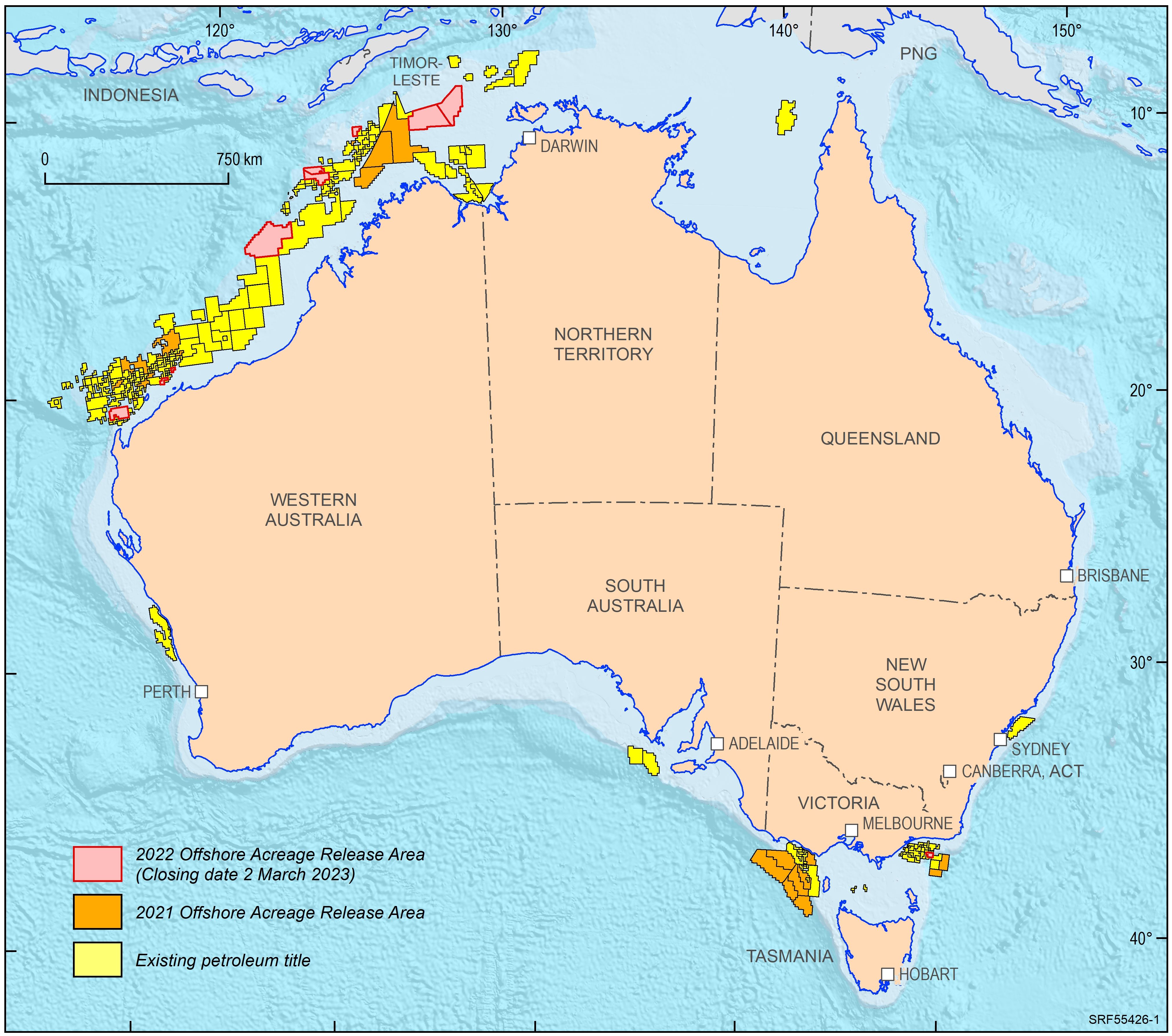
<div>In 2022, the Australian Government released ten offshore petroleum exploration areas. They are located in the Bonaparte Basin, Browse Basin, Northern Carnarvon Basin and Gippsland Basin. The areas highlight that producing provinces rather than data-poor regions are the preferred targets for exploration activities. In addition, the transition to low carbon energy resources, including opportunities for carbon capture and storage, has seen a diversification of energy companies’ portfolios. The Australian Government is supportive of the upstream energy industry, with natural gas seen as an important enabling energy resource commodity that supports the expansion of low emission technologies and related infrastructure. Most of the areas being offered for exploration in 2022 are likely to generate extra volumes of natural gas, both for domestic markets as well as securing feedstock for existing LNG export projects for the longer term. </div><div>Consistent with the approach of recent releases, only one period for work program bidding has been scheduled. The closing date for all bid submissions is 2 March 2023. </div><div>Geoscience Australia provides pre-competitive data and petroleum geological information in support of industry activities. Its petroleum geological studies aim to improve the understanding of the evolution of hydrocarbon-bearing basins at a regional scale and include a review of source rock and fluid occurrences, their geochemical characteristics, and petroleum systems modelling. Most recent examples include a sedimentological/stratigraphic study that investigates the depositional history of the southern Bonaparte Basin during the late Permian to Early Triassic evaluating the controls on reservoir facies development. A regional petroleum geological study of the Otway Basin, with a focus on the deeper water area and utilising newly industry acquired regional seismic data, provides new insights into the hydrocarbon prospectivity of this largely underexplored offshore part of the basin. Latest results of these studies were presented at this year’s APPEA conference. Large seismic and well data sets, submitted under the Offshore Petroleum and Greenhouse Gas Storage Act 2006 (OPGSSA) are made available through the National Offshore Petroleum Information Management System (NOPIMS). Additional data and petroleum related information can be accessed through Geoscience Australia’s data repository</div><div><br></div>
-
<div>The National Geochemical Survey of Australia (NGSA) is Australia’s only internally consistent, continental-scale geochemical atlas and dataset. The present dataset contains additional mineralogical data obtained on NGSA samples selected from the Barkly-Isa-Georgetown (BIG) region of northeastern Australia for the second partial data release of the Heavy Mineral Map of Australia (HMMA) project. The HMMA project, a collaborative project between Geoscience Australia and Curtin University underpinned by a pilot project establishing its feasibility, is part of the Australian Government-funded Exploring for the Future (EFTF) program.</div><div>One-hundred and eighty eight NGSA sediment samples were selected from the HMMA project within the EFTF’s BIG polygon plus an approximately one-degree buffer. The samples were taken on average from 60 to 80 cm depth in floodplain landforms, dried and sieved to a 75-430 µm grainsize fraction, and the contained heavy minerals (HMs; i.e., those with a specific gravity > 2.9 g/cm3) were separated by dense fluids and mounted on cylindrical epoxy mounts. After polishing and carbon-coating, the mounts were subjected to automated mineralogical analysis on a TESCAN® Integrated Mineral Analyzer (TIMA). Using scanning electron microscopy and backscatter electron imaging integrated with energy dispersive X-ray analysis, the TIMA identified 151 different HMs in the BIG area. The dataset, consisting of over 18 million individual mineral grains, was quality controlled and validated by an expert team. The data released here can be visualised, explored and downloaded using an online, bespoke mineral network analysis (MNA) tool built on a cloud-based platform. Preliminary analysis suggests that copper minerals cuprite and chalcopyrite may be indicative of base-metal/copper mineralisation in the area. Accompanying this report are two data files of TIMA results, and a minerals vocabulary file. </div><div>When completed in 2023, it is hoped the HMMA project will positively impact mineral exploration and prospectivity modelling around Australia, as well as have other applications in earth and environmental sciences.</div>
-
<div>This study was commissioned by Geoscience Australia (GA) to produce a report on seal capacity of select samples from the deep stratigraphic hole NDI Carrara 1, located in the Proterozoic Carrara Sub-basin in the Northern Territory. Plugs were taken from depths of interest and analysed via mercury injection capillary pressure testing. Results were provided as two reports, Part A and Part B and demonstrate that the analysed samples are capable of sealing very large columns of both methane and carbon dioxide.</div>
-
<div>Geoscience Australia’s Onshore Basin Inventories program provides a whole-of-basin inventory of geology, energy systems, exploration status and data coverage of onshore Australian basins. Volume 1 of the inventory covers the McArthur, South Nicholson, Georgina, Wiso, Amadeus, Warburton, Cooper and Galilee basins and Volume 2 expands this list to include the Officer, Perth and onshore Canning basins. These reports provide a single point of reference and create a standardised national inventory of onshore basins. In addition to summarising the current state of knowledge within each basin, the onshore basin inventory identifies critical science questions and key exploration uncertainties that may help inform future work program planning and aid in decision making for both government and industry organisations. Under Geoscience Australia’s Exploring for the Future (EFTF) program, six new onshore basin inventory reports will be delivered. </div><div> </div><div>These reports will be supported by selected value-add products that aim to address identified data gaps and evolve regional understanding of basin evolution and prospectivity. Petroleum system modelling is being undertaken in selected basins to highlight the hydrocarbon potential in underexplored provinces, and seismic reprocessing and regional geochemical studies are underway to increase the impact of existing datasets. The inventories are supported by the ongoing development of the nationwide source rock and fluids atlas, accessed through Geoscience Australia’s Exploring for the Future Data Discovery Portal, which continues to improve the veracity of petroleum system modelling in Australian onshore basins.</div><div> </div><div>In summarising avenues for further work, the Onshore Basin Inventories program has provided scientific and strategic direction for pre-competitive data acquisition under the EFTF work program. Here, we provide an overview of the current status of the Onshore Basin Inventories, with emphasis on its utility in shaping EFTF data acquisition and analysis, as well as new gap-filling data acquisition</div> This Abstract was submitted/presented at the 2023 Australasian Exploration Geoscience Conference (AEGC) 13-18 March (https://2023.aegc.com.au/)
-
<div>Lateral variation in maturity of potential Devonian source rocks in the Adavale Basin have been investigated using nine 1D burial thermal and petroleum generation history models, constructed using existing open file data. These models provide an estimate of the hydrocarbon generation potential of the basin. Total organic carbon (TOC) content and pyrolysis data indicate that the Log Creek Formation, Bury Limestone and shale units of the Buckabie Formation have the most potential as source rocks. The Log Creek Formation and the Bury Limestone are the most likely targets for unconventional gas exploration.</div><div> </div><div>The models were constructed used geological information from well completion reports to assign formation tops and stratigraphic ages to then forward-model the evolution of geophysical parameters. The rock parameters, including facies, temperature, organic geochemistry/petrology, were used to investigate source rock quality, maturity and kerogen type. Suitable boundary conditions were assigned for paleo-heat flow, paleo-surface temperature and paleo-water depth. The resulting models were calibrated using bottom hole temperature and measured vitrinite reflectance data.</div><div> </div><div>The results correspond relatively well with published heat flow predictions, however a few wells show possible localised heat effects that differ from the overall basin average. The models indicate full maturation of the Devonian source rocks with generation occurring during the Carboniferous and again during the Late Cretaceous. Any potential accumulations may be trapped in Devonian sandstone, limestone and mudstone units, as well as overlying younger sediments of the Mesozoic Eromanga Basin. Accumulations could be trapped by localised deposits of the Cooladdi Dolomite and other marine, terrestrial clastic and evaporite units around the basin. Migration of the expelled hydrocarbons may be restricted by overlying regional seals, such as the Wallumbilla Formation of the Eromanga Basin. Unconventional hydrocarbons are a likely target for the Adavale Basin with potential either for tight or shale gas in favourable areas from the Log Creek Formation and Bury Limestone.</div> This Abstract was submitted/presented to the 2023 Australian Exploration Geoscience Conference 13-18 Mar (https://2023.aegc.com.au/)
-
<div>Two new programs at Geoscience Australia are providing trusted, high-quality science to support decision making and the Australian resources industry. </div><div> </div><div>The Trusted Environmental and Geological Information program will provide baseline pre-competitive data in the Cooper, Adavale, north Bowen and Galilee basin regions. A repository of information is being developed in collaboration with CSIRO, including new geological and environmental assessments, to accelerate development in the sectors of petroleum, mineral, hydrogen and carbon capture and storage, while simultaneously providing opportunities to understand the potential hazards, risk and impacts of these resources being developed. </div><div> </div><div>The Data Driven Discoveries program is combining new and old data to better understand the under-explored Adavale Basin in central-western Queensland. The program will undertake chemical composition analyses to support the correlation of geological layers, collate and reprocess historical seismic data, acquire new seismic reflection data, and undertake stratigraphic research drilling to provide a more detailed understanding of basin architecture and the resource potential of the Adavale Basin. </div><div> </div><div>An overview of the Trusted Environmental and Geological Information and Data Driven Discoveries programs will be provided, including initial results and planned acquisition. This will show how these complementary programs will contribute to streamlined regulation and approval processes, the low emissions agenda, and responsible resource development in key basin regions across Australia.</div> This Abstract was submitted/presented to the 2022 Petroleum Exploration Society of Australia (PESA) QLD Symposium 9 September (https://pesa.com.au/events/pesa-qld-2022-symposium/)